A LiDAR viewer turns any US address into a 3D map — slope, roof, trees, floodplain, drainage, views. Seven property questions you can answer in five minutes.
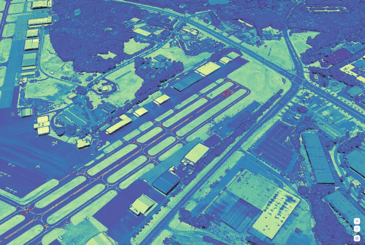
Aerial LiDAR is a public 3D dataset flown over most of the US that shows the real shape of a property — the grade of the yard, the pitch of the roof, the height of every tree, the exact elevation of the lot above the creek behind it. It's one of the most useful pieces of data you can look at before deciding whether to buy, bid, visit, or build. Almost nobody outside of engineering firms and land surveyors currently uses it, because until recently it lived inside desktop GIS software with a multi-hour learning curve and files measured in gigabytes.
What changed: you can now type an address into a browser, load the 3D point cloud in seconds, and answer a stack of questions that used to require driving out, climbing a ladder, or hiring a surveyor. This article walks through the seven questions it answers best — with the specific stats that make each answer credible — and is honest about the ones where it doesn't replace a site visit.
The listing photo is taken from the flattest spot. Your eye is forgiving to grade. Google Earth's terrain is averaged from a 30-meter raster. None of those tell you whether the "flat backyard" drops eleven feet to the fence, whether the driveway is steeper than the 10% max for concrete without a special finish, or whether the "level building site" is actually a natural bench that saves $40,000 in cut-and-fill.
Aerial LiDAR tells you directly. In the viewer, you tilt the view and drag across the parcel; the 3D shape is the 3D shape. Public aerial data in the US is accurate to about 10 cm vertically in open ground, and you can read grade changes down to the foot.
What the pros do with it. A North Carolina horse-farm owner used a LiDAR scan of a new property to identify a natural bench the walking survey had missed, and reported saving roughly $42,000 in barn-pad prep by moving the build forty yards. Contractors routinely use public LiDAR for pre-bid cut/fill estimates; a formal ground survey at $1,500–$10,000 gets deferred until the project is real.
Where it fails. Heavy undergrowth (ferns, brush, scrub) reduces ground accuracy to roughly 30 cm or worse. Under dense conifer canopy, fewer pulses reach the ground. The lot you care most about is often the lot where LiDAR is least reliable — you still need to walk it.
Roof pitch, ridge geometry, azimuth, and shading from the neighbor's maple in November — all visible in the viewer. For anyone evaluating a property for solar, this is the answer to "should I keep going?"
The National Renewable Energy Laboratory validated remote LiDAR-based shading estimates against on-site readings from a SunEye shade finder — the industry standard for physical roof shade measurement. The LiDAR-derived numbers came within about 3.5% of the SunEye values. Close enough that some state solar incentive programs (the Connecticut Green Bank and NYSERDA among them) now accept LiDAR-derived shade reports in lieu of a physical site visit.
Practical implication: if you want to know whether the south slope of your roof is viable for panels, you can get a credible answer in sixty seconds without anyone climbing the house.
Where it fails. At the common 2-points-per-square-meter baseline, small roof obstructions — plumbing vents, satellite dishes, mid-roof AC condensers — often don't show up. A rough kW estimate survives this; a final panel layout doesn't. And if the flight happened before solar panels were installed on the house, obviously the panels aren't in the data.
FEMA flood zones are accurate at the regional level and coarse at the parcel edge. Your address sits in zone AE or zone X, but the line between them runs somewhere across your lot — and a few vertical feet in either direction decides whether a lender requires flood insurance, what it costs, and whether the house can be legally expanded.
A LiDAR-derived ground elevation answers this per parcel. If your lot sits three feet above the base flood elevation on the county FEMA panel, that's different from sitting two feet below it, and those feet are visible in the LiDAR in a way they aren't on any public flood map.
What the pros do with it. Elevation Certificates (the document that determines your flood insurance rate) are produced by a licensed surveyor, but the surveyor often uses public LiDAR to pre-screen — confirming whether the formal survey will be a formality or a problem before scheduling the site visit. Buyers can do the same screening themselves before writing the offer.
Where it fails. This is still a screening tool, not a document. If flood insurance is in play, you still need the survey. And recent work — bulk fill added to a lot, a house raised on piers, a new levee — won't show up until the next flight.
A satellite image shows "trees." LiDAR tells you whether that means four mature sixty-foot oaks with a clear understory, a thicket of twelve-foot scrub, or a single legacy pine flanked by hedge.
This matters more than people assume. Clearing costs scale with canopy volume and species. View screening scales with canopy height and density. Lakefront buyers in Maine, New Hampshire, and Michigan face strict shoreland zoning that limits how much you can cut to "open a view" — and the answer to "can I actually get the water view after a legal thinning?" is a canopy-height question LiDAR answers directly before you make the offer.
For rural-land buyers, canopy height models built from LiDAR have been validated at roughly R² = 0.92 against field measurements — strong enough that land-management consultants use LiDAR as the first pass of a timber cruise, then send crews to verify the stands that matter. A full physical cruise runs $5–$15 per acre and takes weeks; the LiDAR screen costs nothing and takes minutes.
Where it fails. LiDAR doesn't distinguish tree species, health, or merchantability. A canopy height model shows a 70-foot tree; it doesn't tell you whether it's a valuable hardwood or a diseased softwood. For anything with money on the line, LiDAR narrows the field, a forester closes the deal.
You can't see water in aerial LiDAR — water bodies actually read as empty holes because near-infrared laser pulses don't return off water. But you can see exactly where water wants to go: low spots in the yard, the shape of natural drainage swales, the pitch of the street, whether runoff from the uphill neighbor sheets toward your foundation or away from it.
This is one of the quieter wins. A drainage problem that reveals itself during the first spring storm is a $15,000–$50,000 surprise. The shape of the ground — in LiDAR, before a drop of rain falls — tells you which way the surprise will go.
What the pros do with it. Civil engineers use public LiDAR to run preliminary hydrologic models on sites before spending client money on a ground survey. A residential-scale version of the same analysis runs through your head in about two minutes when you look at a point cloud of the lot with the elevation ramp turned on.
Where it fails. LiDAR shows surface topography, not subsurface drainage. Buried tile, French drains, septic fields, the direction the old dry well used to run — none of it is visible. And because water itself is empty in the data, you can't see ponding unless it's shaped by the ground.
This is the feature that sells LiDAR to rural-land buyers, and it's the one Google Earth simply can't do.
Aerial LiDAR fires multiple pulses per square meter, and each pulse typically produces several returns — the first return hits the top of the tree canopy, and later returns punch through to branches or the ground below. In a LiDAR viewer you can filter the display to show only the last return of each pulse — the one that made it farthest through the canopy. When the flight was captured leaf-off (late winter or early spring, which is when most public capture is deliberately scheduled in deciduous regions), more than 90% of pulses reach the forest floor.
That means on wooded parcels you can see the shape of the ground under the trees: old logging roads, the footprint of a demolished barn, a collapsed stock tank, an earthen dam, historic road prisms, archaeological features. Any buyer evaluating a rural tract is effectively blind under canopy if they're only looking at satellite imagery. LiDAR lifts the roof.
What the pros do with it. Archaeologists routinely surface pre-contact earthworks, colonial foundations, and Civil War fortifications by filtering leaf-off LiDAR to last returns and rendering the result as a hillshade. Land investors use the same trick to spot access routes and home sites on forested parcels before the site visit.
Where it fails. Dense evergreen canopy (Pacific Northwest conifers, Southeast pines in summer) drops the percentage of pulses reaching the ground dramatically. Leaf-on deciduous flights are less useful for this trick than leaf-off. And if a tile is more than a year or two old, any recent undergrowth, fallen trees, or new trails won't be in the data.
Take the 3D shape of a proposed development — even if you only have the site plan and the stated building heights — and compare it against the existing LiDAR of the parcels around it. Will the new three-story townhomes block the morning sun on your solar panels? Will the proposed office pad rise above the treeline between it and your house? Will the cell tower's shadow reach your porch in the afternoon?
This use case is quietly growing. Zoning and land-use hearings are quasi-judicial; decisions are supposed to be based on "substantial evidence in the record," not neighbors' opinions. A printed LiDAR cross-section showing existing elevation along a shared property line, with a proposed structure drawn in at the stated height, is exactly the kind of factual record that carries weight. For any homeowner who has ever been told by a developer that "the site is flat" or "the building won't affect your view," LiDAR is the first chance to bring 3D evidence to the hearing without hiring a civil engineer.
Where it fails. LiDAR shows the world as it was on flight day. It doesn't predict post-development drainage, it doesn't model proposed grades, and it doesn't capture what's inside the developer's CAD file. It's a "here's what's there now" tool, not a "here's what they'll build" simulator. For a formal sightline study you still need a stormwater model and a civil review.
Worth being blunt about this.
LiDAR is a screening, context, and due-diligence tool. For anything that gets stamped, signed, or sued over, it's the start of the process, not the end.
As of the end of federal fiscal year 2025, roughly 99% of the continental US has aerial LiDAR available or in progress. Alaska is the biggest remaining gap. For a given address in the lower 48, the data was captured somewhere between one and eight years ago, depending on your county's refresh program, disaster-driven re-flights, and whether your state funded higher-resolution collection.
Fast-growing metros tend to be newer. Rural areas tend to be older. Recent major disasters — wildfires, hurricanes, tornadoes — trigger re-flights within weeks. Anything built in the last year or two is probably not in the data yet; check a current satellite pass if recency is load-bearing for the decision.
D).The LiDAR view sits in the same workspace as travel-time maps, demographics, and trade-area scoring — the address you paste is the address the rest of the tools already know about. That's the reason to use this instead of a standalone viewer: you're not collecting tools, you're answering questions about a place.
Can LiDAR see my property lines?
No. Parcel boundaries come from county records, not the laser. LiDAR shows what's physically on the ground — houses, fences, pavement, trees — but the legal lines are a separate overlay. Use the county GIS or a title survey for those.
How accurate is it compared to a surveyor?
Public aerial LiDAR is accurate to roughly 10 cm vertically in open terrain — much better than consumer GPS but not as tight as a licensed RTK survey (1–3 cm). For screening and decision support, LiDAR is usually enough. For anything stamped or signed, you still need the surveyor.
Can anyone see LiDAR of my house?
Public aerial LiDAR covers most of the US, and yes, it's available to anyone with a viewer. It shows the shape of structures visible from the air — roof, outbuildings, trees, pool. It doesn't see through walls, doesn't show the inside of anything, and isn't high enough resolution to identify people or vehicles.
What if my address isn't covered?
A small fraction of the country still has gaps — mostly in remote Alaska and a handful of western counties. The viewer tells you when coverage isn't available rather than showing bad data as if it were good.
Is the LiDAR free?
The underlying data is public information collected by federal and state programs. The viewer — the part that turns it into something usable without GIS software.
For most US addresses, aerial LiDAR answers slope, roof viability, flood precision, tree cover, drainage, hidden-under-canopy features, and proposed-construction sightlines — in minutes, in a browser, with accuracy that holds up for screening decisions. It's not a replacement for a surveyor, a forester, or a site visit. It's a free-to-look first pass that most buyers, owners, and neighbors have never used.
 RadiusMapper